


Page 82 - Demo
P. 82
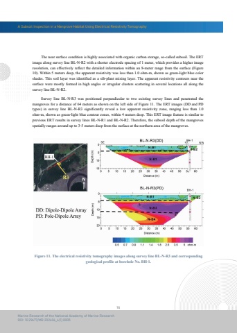
A Subsoil Inspection in a Mangrove Habitat Using Electrical Resistivity Tomography70Marine Research of the National Academy of Marine ResearchDOI: 10.29677/MR.202406_4(1).0005 The near surface condition is highly associated with organic carbon storage, so-called subsoil. The ERTimage along survey line BL-N-R2 with a shorter electrode spacing of 1 meter, which provides a higher image resolution, can effectively reflect the detailed information within an 8-meter range from the surface (Figure 10). Within 5 meters deep, the apparent resistivity was less than 1.0 ohm-m, shown as green-light blue color shades. This soil layer was identified as a silt-plant mixing layer. The apparent resistivity contours near the surface were mostly formed in high angles or irregular clusters scattering in several locations all along the survey line BL-N-R2. Survey line BL-N-R3 was positioned perpendicular to two existing survey lines and penetrated themangroves for a distance of 64 meters as shown on the left side of Figure 11. The ERT images (DD and PD types) in survey line BL-N-R3 significantly reveal a low apparent resistivity zone, ranging less than 1.0 ohm-m, shown as green-light blue contour zones, within 4 meters deep. This ERT image feature is similar to previous ERT results in survey lines BL-N-R1 and BL-N-R2. Therefore, the subsoil depth of the mangroves spatially ranges around up to 3-5 meters deep from the surface at the northern area of the mangroves.Figure 11. The electrical resistivity tomography images along survey line BL-N-R3 and correspondinggeological profile at borehole No. BH-1.


