


Page 81 - Demo
P. 81
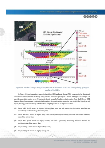
A Subsoil Inspection in a Mangrove Habitat Using Electrical Resistivity Tomography69Marine Research of the National Academy of Marine ResearchDOI: 10.29677/MR.202406_4(1).0005Figure 10. The ERT images along survey lines BL-N-R1 and BL-N-R2 and corresponding geologicalprofile at No. BH-1. In Figure 10, two inspection types, dipole-diploe (DD) and pole-dipole (PD), were applied to the subsoil detection in survey line BL-N-R1 by using a wider electrode spacing of 2 meters. PD-type ERT images can provide more information up to 30 meters in depth, instead of shallower information from the DD-type ERT images. Based on apparent resistivity information, the stratigraphic properties can be divided into five soil layers, having good consistency with borehole sampling at BH-1, as explained beloLayer NB1 (0-0.3 meters in depth): Mixing plant roots and silt; unobvious horizontal interface and sporadically scattered along the survey line;(1)Layer NB2 (0-5 meters in depth): Silty sand with a gradually increasing thickness toward the northeast side of the survey line;(2)Layer NB3 (5-15 meters in depth): Sandy silt with a gradually decreasing thickness toward the northwest side of the survey line;(3)(4) Layer NB4 (15-25 meters in depth): Silty sand;(5) Layer NB5 (>25 meters in depth): Sandy silt.


