


Page 84 - Demo
P. 84
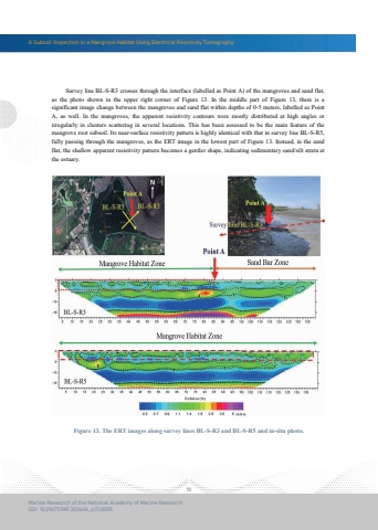
A Subsoil Inspection in a Mangrove Habitat Using Electrical Resistivity Tomography72Marine Research of the National Academy of Marine ResearchDOI: 10.29677/MR.202406_4(1).0005 Survey line BL-S-R3 crosses through the interface (labelled as Point A) of the mangroves and sand flat, as the photo shown in the upper right corner of Figure 13. In the middle part of Figure 13, there is a significant image change between the mangroves and sand flat within depths of 0-5 meters, labelled as Point A, as well. In the mangroves, the apparent resistivity contours were mostly distributed at high angles or irregularly in clusters scattering in several locations. This has been assessed to be the main feature of themangrove root subsoil. Its near-surface resistivity pattern is highly identical with that in survey line BL-S-R5, fully passing through the mangroves, as the ERT image in the lowest part of Figure 13. Instead, in the sand flat, the shallow apparent resistivity pattern becomes a gentler shape, indicating sedimentary sand/silt strata at the estuary.Figure 13. The ERT images along survey lines BL-S-R3 and BL-S-R5 and in-situ photo.


