


Page 86 - Demo
P. 86
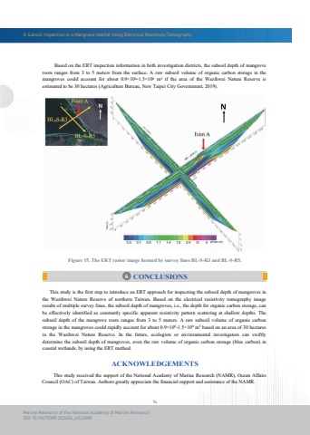
A Subsoil Inspection in a Mangrove Habitat Using Electrical Resistivity Tomography74Marine Research of the National Academy of Marine ResearchDOI: 10.29677/MR.202406_4(1).00056 CONCLUSIONS This study received the support of the National Academy of Marine Research (NAMR), Ocean Affairs Council (OAC) of Taiwan. Authors greatly appreciate the financial support and assistance of the NAMR.ACKNOWLEDGEMENTSFigure 15. The ERT raster image formed by survey lines BL-S-R3 and BL-S-R5. This study is the first step to introduce an ERT approach for inspecting the subsoil depth of mangroves in the Wazihwei Nature Reserve of northern Taiwan. Based on the electrical resistivity tomography image results of multiple survey lines, the subsoil depth of mangroves, i.e., the depth for organic carbon storage, can be effectively identified as constantly specific apparent resistivity pattern scattering at shallow depths. The subsoil depth of the mangrove roots ranges from 3 to 5 meters. A raw subsoil volume of organic carbon storage in the mangroves could rapidly account for about 0.9%u00d7106-1.5%u00d7106 m3 based on an area of 30 hectares in the Wazihwei Nature Reserve. In the future, ecologists or environmental investigators can swiftly determine the subsoil depth of mangroves, even the raw volume of organic carbon storage (blue carbon) in coastal wetlands, by using the ERT method. Based on the ERT inspection information in both investigation districts, the subsoil depth of mangroveroots ranges from 3 to 5 meters from the surface. A raw subsoil volume of organic carbon storage in the mangroves could account for about 0.9%u00d7106-1.5%u00d7106 m3 if the area of the Wazihwei Nature Reserve is estimated to be 30 hectares (Agriculture Bureau, New Taipei City Government, 2019).


