


Page 76 - Demo
P. 76
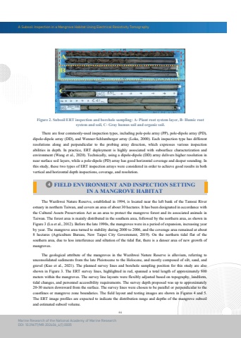
A Subsoil Inspection in a Mangrove Habitat Using Electrical Resistivity Tomography64Marine Research of the National Academy of Marine ResearchDOI: 10.29677/MR.202406_4(1).0005 The Wazihwei Nature Reserve, established in 1994, is located near the left bank of the Tamsui Riverestuary in northern Taiwan, and covers an area of about 30 hectares. It has been designated in accordance withthe Cultural Assets Preservation Act as an area to protect the mangrove forest and its associated animals in Taiwan. The forest area is mainly distributed in the southern area, followed by the northern area, as shown in Figure 3 (Lu et al., 2012). Before the late 1990s, the mangroves were in a period of expansion, increasing year by year. The mangrove area turned to stability during 2000 to 2006, and the coverage area remained at about 8 hectares (Agriculture Bureau, New Taipei City Government, 2019). On the northern tidal flat of the southern area, due to less interference and siltation of the tidal flat, there is a denser area of new growth of mangroves. There are four commonly-used inspection types, including pole-pole array (PP), pole-dipole array (PD),dipole-dipole array (DD), and Wenner-Schlumberger array (Loke, 2000). Each inspection type has different resolutions along and perpendicular to the probing array direction, which expresses various inspection abilities in depth. In practice, ERT deployment is highly associated with subsurface characterization and environment (Wang et al., 2020). Technically, using a dipole-dipole (DD) array delivers higher resolution in near surface soil layers, while a pole-dipole (PD) array has good horizontal coverage and deeper sounding. In this study, these two types of ERT inspection arrays were considered in order to achieve good results in both vertical and horizontal depth inspections, coverage, and resolution.Figure 2. Subsoil ERT inspection and borehole sampling: A- Plant root system layer, B- Humic rootsystem and soil, C- Gray humus soil and organic soil.4 FIELD ENVIRONMENT AND INSPECTION SETTINGIN A MANGROVE HABITAT The geological attribute of the mangroves in the Wazihwei Nature Reserve is alluvium, referring to unconsolidated sediments from the late Pleistocene to the Holocene, and mostly composed of silt, sand, and gravel (Kuo et al., 2021). The planned survey lines and borehole sampling position for this study are also shown in Figure 3. The ERT survey lines, highlighted in red, spanned a total length of approximately 800 meters within the mangroves. The survey line layouts were flexibly adjusted based on topography, landform,tidal changes, and personnel accessibility requirements. The survey depth proposed was up to approximately 20-30 meters downward from the surface. The survey lines were chosen to be parallel or perpendicular to thecoastlines or mangrove zone boundaries. The field layout and testing images are shown in Figures 4 and 5. The ERT image profiles are expected to indicate the distribution range and depths of the mangrove subsoil and estimated subsoil volume.


