


Page 104 - Demo
P. 104
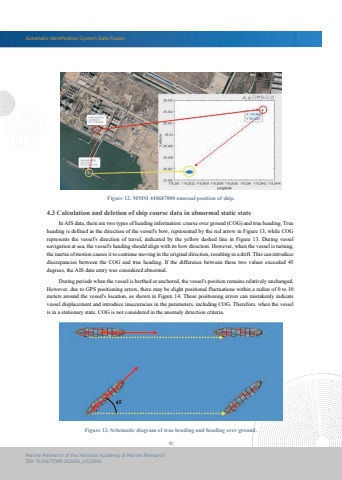
Automatic Identification System Data Fusion92Marine Research of the National Academy of Marine ResearchDOI: 10.29677/MR.202406_4(1).0006Figure 12. MMSI 440687000 unusual position of ship. In AIS data, there are two types of heading information: course over ground (COG) and true heading. True heading is defined as the direction of the vessel's bow, represented by the red arrow in Figure 13, while COG represents the vessel's direction of travel, indicated by the yellow dashed line in Figure 13. During vessel navigation at sea, the vessel's heading should align with its bow direction. However, when the vessel is turning, the inertia of motion causes it to continue moving in the original direction, resulting in a drift. This can introducediscrepancies between the COG and true heading. If the difference between these two values exceeded 45 degrees, the AIS data entry was considered abnormal. During periods when the vessel is berthed or anchored, the vessel's position remains relatively unchanged. However, due to GPS positioning errors, there may be slight positional fluctuations within a radius of 0 to 10 meters around the vessel's location, as shown in Figure 14. These positioning errors can mistakenly indicate vessel displacement and introduce inaccuracies in the parameters, including COG. Therefore, when the vessel is in a stationary state, COG is not considered in the anomaly detection criteria.4.3 Calculation and deletion of ship course data in abnormal static stateFigure 13. Schematic diagram of true heading and heading over ground.


