


Page 102 - Demo
P. 102
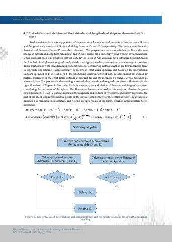
Automatic Identification System Data Fusion90Marine Research of the National Academy of Marine ResearchDOI: 10.29677/MR.202406_4(1).0006Figure 9. The process for determining abnormal latitude and longitude positions along with abnormalheading. To determine if the stationary position of the same vessel was abnormal, we selected the current AIS data and the previously received AIS data, defining them as D1 and D2, respectively. The great circle distance,denoted as d, between D1 and D2 was then calculated. The purpose was to assess whether the linear distance change in latitude and longitude between D1 and D2 was normal for a stationary vessel without any acceleration. Upon examination, it was observed that the GPS devices used in AIS data may have introduced fluctuations in the fourth decimal place of longitude and latitude readings, even when there was no actual change in position. These fluctuations were considered as positioning errors. Considering that the length of the fourth decimal place in longitude and latitude is approximately 10 meters of great circle distance, and based on the internationalstandard specified in ITU-R M.1371-5, the positioning accuracy error of GPS devices should not exceed 10 meters. Therefore, if the great circle distance d between D1 and D2 exceeded 10 meters, it was classified as abnormal data. The process for determining abnormal ship latitude and longitude positions is illustrated in the right flowchart of Figure 9. Since the Earth is a sphere, the calculation of latitude and longitude requiresconsidering the curvature of the sphere. The Haversine formula was used in this study to calculate the great circle distance (1). %u03bb1, %u03d51, %u03bb2, and %u03d52 represent the longitude and latitude of two points, and hav(%u03b8) represents the half of the chord length between two points on the surface of the sphere for the central angle %u03b8. The great circle distance d is measured in kilometers, and r is the average radius of the Earth, which is approximately 6,371 kilometers.4.2 Calculation and deletion of the latitude and longitude of ships in abnormal static state


