


Page 44 - Demo
P. 44
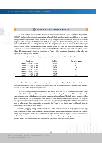
Acoustic Distribution Maps of Phonating Species in Coral Reefs32Marine Research of the National Academy of Marine ResearchDOI: 10.29677/MR.202406_4(1).0003Table 1. Recording sessions by the silent platform off Sesoko Island. The silent platform was operated in the eastern and southern waters off Sesoko Island from August 16 to 18, 2017. Each recording session is summarized in Table 1. Each recording session lasted 1 hour or less due to the operator's resting intervals. In case the wind picked up, the operation was terminated. Temporal termination happened when an engine boat approached at 15:31 on August 17. We avoided entering the area close to the main island of Okinawa as a safety measure since it is frequently used by local private boats and passenger vessels. Sesoko Island is connected by a bridge, which is shown as a black line at the north-east of the island (Figure 3). The Sesoko Marine Research Station is indicated by the red circle at the south-east side of Sesoko Island. The trajectories are shown in white lines in Figure 3 (C). In addition, black dots on the color maprepresent the GPS uplinked positions. Sound densities of damselfish and snapping shrimp are depicted in Figure 3. The color scale indicates the number of sounds detected in each area (a rectangular mesh) for damselfish and the accumulated band intensity of around 8,000 Hz for snapping shrimp sounds. The sound density distribution of damselfish was patchy. The coral reef on the east side of Sesoko Island extends 50 to 100 m offshore and is nearly continuously distributed along the shore line. The damselfish sounds were not always observed in the corals, but rather concentrated in small areas. The high-density acoustic patcheswere recorded off the reef, possibly over coral patches or large isolated massive coral colonies. This suggests that a group of damselfish actively phonated in a specific area, possibly breeding spots, and kept silent or moved away to other areas. Since interpolation was applied for Figure 3, low density gaps could result from the interpolation calculation of sound density. In contrast, snapping shrimp sounds were observed in the entire coastal waters. Very high acoustic energy spots were observed south of the bridge between Sesoko Island and the main island, shown in dark red. Notably, a large high-energy area existed in the southern area of Sesoko Island, where highly developed coral reefs can be found. Because many crustaceans inhabit coral reefs and produce high-energy pulse sounds, the current acoustic map of snapping shrimp could represent the crustaceans' activity in the coral reefs.3 RESULTS AND DISCUSSION


